Back سامرلند، کالیفورنیا AZB Summerland (Califòrnia) Catalan Саммерленд (Калифорни) CE Summerland (lungsod sa Tinipong Bansa) CEB Summerland (California) Spanish Summerland (Kalifornia) Basque سامرلند، کالیفرنیا Persian Summerland (Californie) French Summerland (Kalifornija) Croatian Summerland (California) Italian
Summerland, California | |
|---|---|
 Summerland, as seen from the top of Ortega Hill, 2006 | |
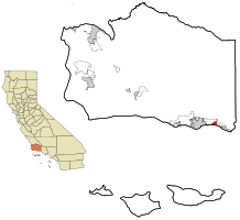
 Location in Santa Barbara County and the state of California | |
| Coordinates: 34°25′17″N 119°35′45″W / 34.42139°N 119.59583°W | |
| Country | |
| State | |
| County | Santa Barbara |
| Government | |
| • State senator | Monique Limón (D)[1] |
| • Assemblymember | Gregg Hart (D)[1] |
| • U. S. rep. | Salud Carbajal (D)[2] |
| Area | |
| • Total | 1.990 sq mi (5.152 km2) |
| • Land | 1.983 sq mi (5.135 km2) |
| • Water | 0.007 sq mi (0.017 km2) 0.33% |
| Elevation | 121 ft (37 m) |
| Population | |
| • Total | 1,448 |
| • Density | 730/sq mi (280/km2) |
| Time zone | UTC-8 (Pacific) |
| • Summer (DST) | UTC-7 (PDT) |
| ZIP code | 93067 |
| Area code | 805 |
| FIPS code | 06-75714 |
| GNIS feature ID | 1656637 |
Preview warning: Page using Template:Infobox settlement with unknown parameter "meaning_name"
Summerland is a census designated place (CDP) in Santa Barbara County, California. The population was 1,448 at the 2010 census, down from 1,545 at the 2000 census.
The town includes a school and a Presbyterian Church. There are many small businesses.
- ^ a b "Statewide Database". UC Regents. Archived from the original on February 1, 2015. Retrieved December 8, 2014.
- ^ "California's 24th Congressional District - Representatives & District Map". Civic Impulse, LLC. Retrieved September 29, 2014.
- ^ "2010 Census U.S. Gazetteer Files – Places – California". United States Census Bureau.
- ^ "Summerland". Geographic Names Information System. United States Geological Survey, United States Department of the Interior. Retrieved March 15, 2015.